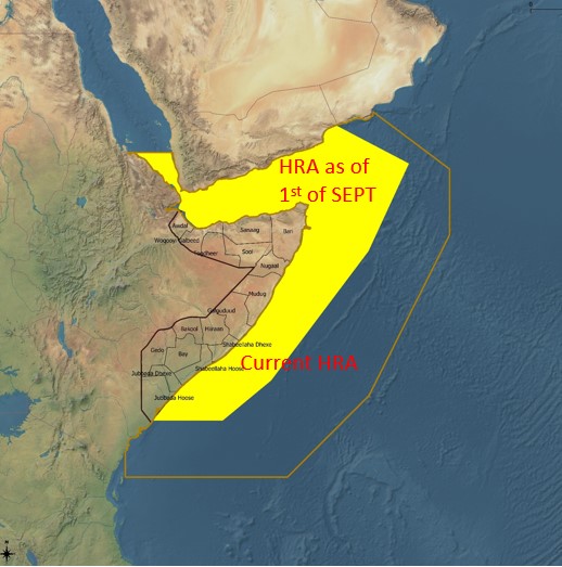
Rota, August 27th, 2021. Following a document submitted from Kenya to the IMO, a thorough threat assessment from the Western Indian Ocean Region based on threat assessments of SHADE and EU NAVFOR ATALANTA, among other agencies, led the Shipping Industry to consider not only to reduce the HRA, but to re-think the scenario, taking into account the new arising threats, and the approach to the response to maritime insecurity in the region from merchant community perspective.
Thanks to the presence and effort of naval forces, as well as the action of private sector and a huge effort in the implementation of ship protection measures by shipping and fishing companies, as outlined by BMP5, Somali piracy is suppressed and has been declining with no attacks registered since 2019, when EU NAVFOR ATALANTA disrupted a piracy attack on FV ADRIA and FV TXORI ARGI, arresting five suspects and releasing the crew of a dhow having been used as mothership.
While the root causes for piracy have not been suppressed yet, Pirate Action Groups and their kingpins have diverted operations to other crimes such as smuggling, exploiting the insecurity created by the Yemeni conflict.
The Shipping Industry considers that the designation of a high-risk area based solely on the threat from Somali piracy is now outdated, and it is required a more dynamic mechanism to account for the changing threat environment in the region. The discussion is about Threat and not Risk (BMP 5, section 3), and in this vein the Shipping Industry states that while the area cannot be deemed to be “High Risk”, it remains the case that maritime security threats are present and thus some designation is required. That will allow the maritime industry to implement ship protection measures based on their voyage risk assessments.
Taking the outcome of threat assessment into consideration, the BMP co-authors believe that a two-step approach should be taken to revise the concept for describing maritime security threats and informing the industry's risk assessment processes.
As a first step, from 1 September the HRA will be amended as follows, covering all threats described in BMP 5, section 2:

From position A (Latitude of 01 30'S on the Somali coast), a line to
Position B (01° 30' S – 046° 00’ E), a line to
Position C (01° 00' N – 049° 30’ E), a line to
Position D (09° 00' N – 055° 00’ E), a line to
Position E (14° 20' N – 057° 30’ E), a line to
Position F (the Yemen coast at longitude 053° 00' E), then
Follow the Yemeni coast westwards and northwards, to
Position G (the Yemeni Red Sea coast at latitude 15° 00' N), then a line to
Position H (the Eritrea territorial sea border at latitude 15° 00' N), then
Follow southwards first Eritrea's and then Djibouti's territorial sea borders, to
Position I (the coastal border point between Djibouti and Somalia), then
Follow the Somali coast eastwards and then southwards, to
Position A.
This new designation is an interim measure to allow for the continued application of BMP 5, while the co-authors undertake substantive work to address maritime security threats in a global context. This second step is anticipated to be completed by 31 December 2021. After this date, a new industry-led security threat assessment will be provided to shipowners and operators.
As it has been the case since its inception, EU NAVFOR ATALANTA will continue to show its commitment to the safety and security of seafarers according to its mandate, which has at the core the duty to protect WFP vessels and other vulnerable ships, whatever their flag could be. In this vein, EU NAVFOR ATALANTA lively recommends to register to MSCHOA Voluntary Registration Scheme as the foundation for EU NAVFOR ATALANTA to assess the vulnerability of vessels transiting or operating across the region, as well as reporting to UKMTO.
Source:
| - Document MSC 104/8/2 submitted by the Shipping Industry - ICS |
